Best Effeciency Dgps Measuring Equipment for Land & Marine Surveying
Springss are one of the most widely used and welcome products in the
market, Agricultural, Industrial, Power equipment, Traffic Equipment,
Construction Equipment, furniture are all need many Springss. High
quality material selection.powerful and precise heat-treatment ability
and excellent assembly methods ensure Borine' Springs meet strong and
high efficiency needs of modern society. Borine' Springs are all by
inspected strictly before shipping tocustomers. Springs Press Spring, Spiral Spring, Extension Spring Ningbo Borine Machinery Co.,Ltd. , http://www.borine-agroparts.com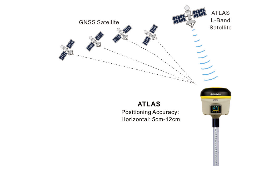
     The GNSS Receiver adopts ATLAS L-Band Satellite Based Augmentation System, Geosynchronous satellite, broadcasting data signals by L-Band to global area, which enables Single Positioning without Ground Base Stations or CORS network, can obtain a cm level accuracy; It can reach high precision easily in the Areas where is not Differential Signals, Desert, Marine, GIS data Collecting, fast single positioning.
Satellite Datalink Continuous Surveying
More continuous surveying, less downtim
     Leveraging a worldwide network of GNSS Reference stations and satellite datalinks, supporting the users obtain a cm level accuracy lasting 30-40 minutes when the satellite datalink breakdown.
Technical Specifications:
MODEL
G10A
Tracking Capability
Number of Channels
372 Channels
Trached Signals
GPS: L1C/A, L1C, L2C, L2EÂ Â Â Â Â Â Â Â Â Â Â GLONASS: L1C/A, L1P, L2C/A, L2PÂ
BDS: B1, B2, B3Galileo: E1, E5A, E5BÂ Â Â Â SBAS: WAAS, ENGOS, GAGAN, MSAS, QZSS Positioning Accuracy
ATLAS
Horizontal: 0.05m - 0.12m                  Vertical: 0.10m - 0.15m
Code differential GNSS positioning (DGPS)
Horizontal: ± 0.25 m + 1 ppm RMS                  Vertical: ± 0.50 m + 1 ppm RMS
SBAS differential positioning accuracy: Typically < 5 m
Static GNSS surveying
Horizontal: ± 2.5 mm + 0.5 ppm RMS              Vertical: ± 5.0 mm + 0.5 ppm RMS
Real Time Kinematic surveying (RTK)
Single Baseline < 30km: Horizontal: ± 8 mm + 1 ppm RMS      Â
Vertical: ± 15 mm + 1 ppm RMSNetwork RTK: Horizontal: ± 8 mm + 0.5 ppm RMS          Â
Vertical: ± 5 mm + 0.5 ppm RMSInitialization time: Typically < 8 seconds     Initialization reliability: Typically > 99.9% Tilt survey (2m GPS pole): 10 degree to 30 degree: 10mm to 30mm Hardware Physical
Size (W × H)
14.1cm × 14cm
Weight
1.45kg with battery
Material
Magnesium alloy shell
Temperature
Operating Temperature: -30ºC ~ +65ºC      Storage Temperature: -40ºC ~ +75ºC
Humidity
100%, condensing
Dust/Water Protection
IP67 at closing all connector caps. Protected agaist temporary immersion up to 1m depth.
Shock and vibration
Designed to survive a 2m natural fall onto concrete
Electrical
Power
9 to 22V DC external power input with over-voltage protection
Rechargeable
Removable 11.1V, 3.4Ah Lithium-ion smart battery with LED status indicators
Input voltage
100 to 240V AC (50/60Hz)
Power consumption
6.2W in RTK rover mode with internal radio
Operating times on single battery
Static mode: 12 hours                   UHF receive only option: 8 hours
UHF receive/transmit option (2.0W): 4.3 hours WCDMA/GPRS receive option: 6 hours Operation system
Button
Double buttons and visual operation interface
LCD
1.2inch HD OLED screen, 128 × 64 dpi sunlight readable
Voice
iVoice intelligent voice technology provides status and operation voice promptly
Communications and Data Storage
Internal Radio
Frequency: 410 ~ 470MHz                         Working range: 3 ~ 5km
Transmitting power: 0.5W/2W adjustable
External Radio
Frequency: 410 ~ 470MHz                         Working range: 8 ~ 30km
Transmitting power: 5W/35W adjustable
Cellular
WCDMA3.5G, GPRS/EDGE (option CDMA2000/EVDO 3G)
Bluetooth
Bluetooth2.1 + EDR/Bluetooth 4.0 BLE
Wi-Fi
802.11 b/g/n, accress point mode
Data storage
Internal Memory: 4GBÂ Â Â Â Â Â Â Â Â Â Â Â Â Â External Memory: Micro SD card (Max.32GB)
Data Formats
1Hz positioning output, up to 20Hz
CMR, CMR+, RTCM2.3, RTCM3.0, RTCM3.1, RTCM3.2 MSM input and output
Web UI
Offers simple configuration, operation, status, and data transfer
Accessible via Wi-Fi, Serial, USB, and Bluetooth I/O port GPRS antenna connector/UHF antenna connector DC power input (5-pin)/RS232 and USB port (7-pin) SIM card slot/1 X Micro SD slot Tilt Survey System Built in tilt compensator, correcting coordinates automatically according to the tilt direction and angle of the centering rod Electronic Bubble Controller software display electronic bubble, checking leveling status of the centering rod real time Data cloud service Web page cloud service management platform, supporting online register etc. 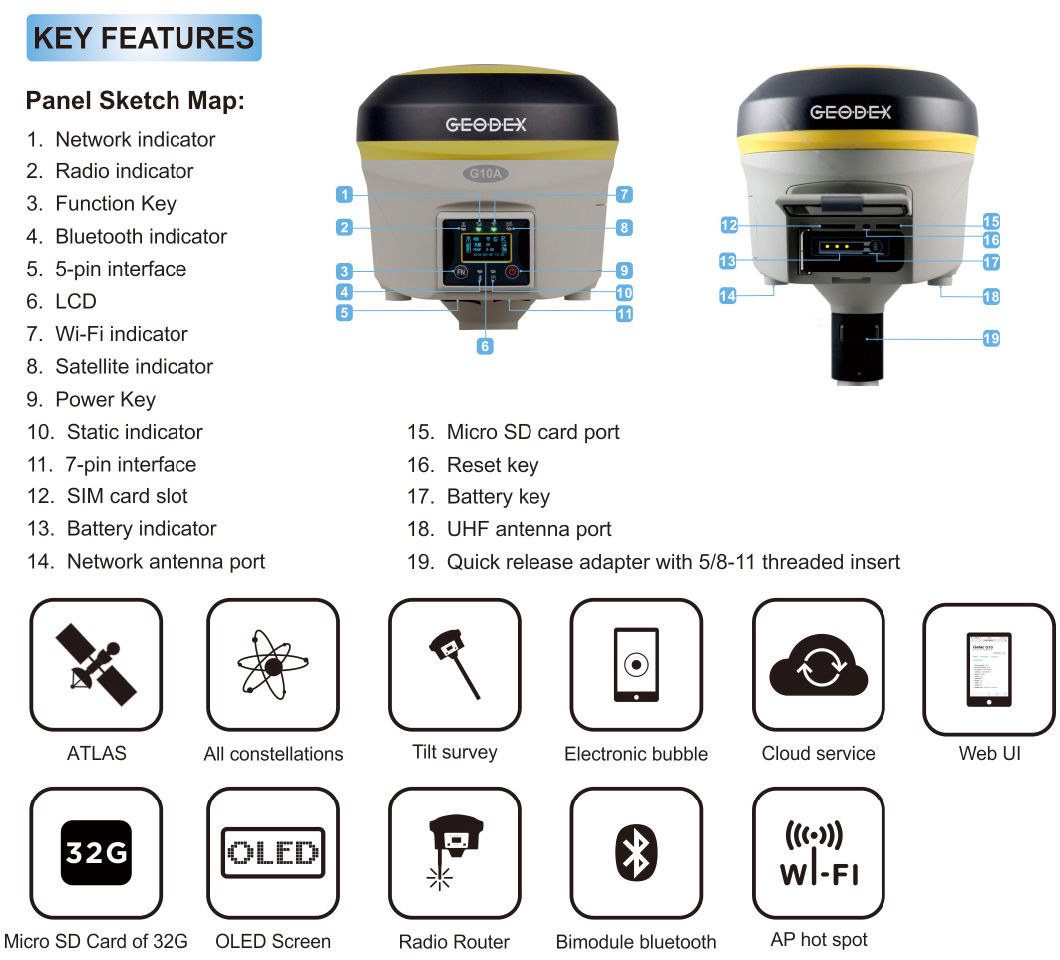
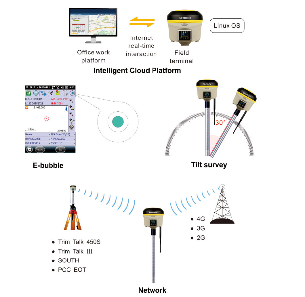
Intelligent Cloud Platform
     The receiver is no longer an independent hardware device, it's a complete intelligent operation system with web page cloud platform.
Â
E-bubble
     The internal Electronic bubble sensor can display the survey status of the receiver on the controller in real time. You don't even need a leveling bubble on the pole anymore.
Â
Tilt survey
     The internal Tilt sensor helps to survey without leveling the receiver, in order to improve survey efficiency. Tilt angle is allowed up to 30 degree. Bulit-in tilt compensator corrects the coordinates according to the direction and tilt angle.
Â
Intelligent data communication Internal radio
     Internal radio module is compatible with current radio protocols in the market, also support all kinds of network types to access CORS seamlessly.
Â
Network
     Adopting new network program frame, it supports all kinds of network types to access CORS seamlessly 3.5G high speed network and is extendable to 4G.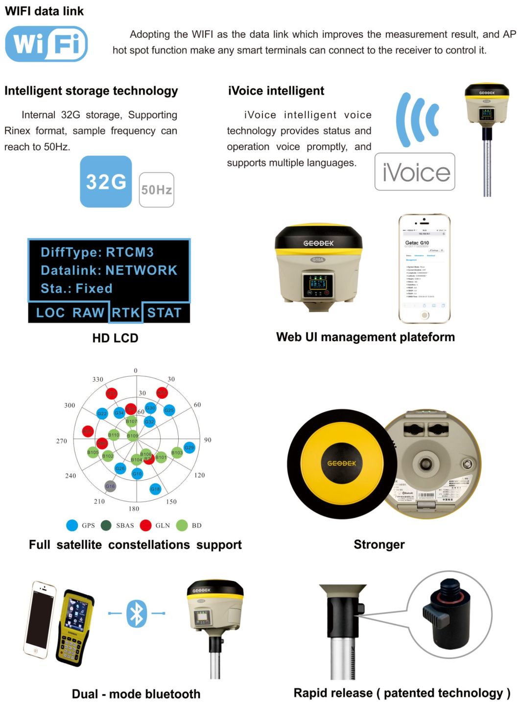
Â
HD LCD
     1.2 inch HD OLED colorful LCD supporting multiple language display and it is suitable fo field work with high brightness and low power consumption.
Â
Web UI management plateform
     The internal Web UI management platform of G10A supports WIFI and USB mode connection. Users can monitor the receiver status and configure it via the internal Web UI management platform.
Â
Full satellite constellations support
     Equipped with most advanced GNSS boards,G10A system can track most signals from all kinds of running satellite constellation, especially support B1, B2, B3 singnal from Beidou, also is able to get position result only with Beidou singnal.
Â
Stronger
     Magnesium alloy materials create an extremely rugged, compact and light machine body for G10A. The anti impact ability, shock absorbing ability and beat dissipation ability are greatly improved.
Â
Dual - mode bluetooth
     Support bluetooth 4.0 long distance transmission, able to connect mainstream phones, tablets and consumer digital products, while compatible with bluetooth 2.1, Connecting industrial grade Handheld Controller.
Â
Rapid release ( patented technology )
    The rapid installation or disassembly of the instrument can be achieved by only one button.
Â
Â
E-Survey Software
1. Power Survey
   Line selection, cross measurement, 4-D Data Format output.
Â
2. Road survey
   Road design, Middle Side Stake Layout, Cross section survey.
Â
3. Base Map Loading
   Support vector data loading such as DXF, SHP and GCP.
Â
4. GIS collection
   Support Attribute Data Collecting by Self-Defined data dictionary and export GIS exchange format.
Â
5. Post Processing Software GGO
   Support to convert the data format into RINEX, which is compatible with AutoCAD and other Drawing & Mapping Software.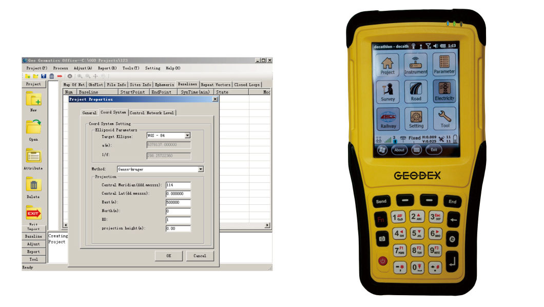
Â